A Nature Walk: Oxford University Parks to Magdalen

Owing to vandalism, Magdalen College has shut the gates leading over the bridge from Addison's Walk, so these days you'd have to do the walk in 2 stages.
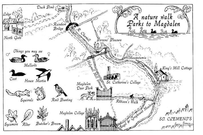
Start at Rainbow Bridge, so called because of its shape. Head south through the parks, exiting at the Linacre College gate, and set off down the cycle path. From here it's a short walk to enter Mesopotamia, though it's worth also exploring the west bank of the two channels, which meanders alongside the Music Meadow. Can you spot the Ore Stabit bench, and indeed the hidden meaning of its inscription?
Back up to the gate, and cross over to the narrow Mesopotamia walkway, and you'll come to the King's Mill Cottage: the watermill on this site was mentioned in the Domesday Book, and operated until 1832. No longer standing, it was replaced by the cottage.
Addison's Walk: dates from the 16th century but was named after Joseph Addison, poet and essayist, Fellow of Magdalen College from 1697-1711 who was fond of walking there.
Angel and Greyhound Meadows: so called after 2 public houses on the High Street which rented the meadows from Magdalen College to provide hay for their horses. The Greyhound was on the corner of Longwall Street, and was demolished in 1851. The Angel stood on the site of the Examination Schools; part survives today in No. 84, the High Street.
Parsons' Pleasure: Strangely, in view of the stories of Victorian prudery generally, they did go in for nude bathing - perhaps the cold water kept them pure! A section of the Cherwell (Parsons' Pleasure) was screened off for nude male bathing only and ladies were supposed to de-punt, walk round and rejoin their male companions further along the river. A few years ago, 3 dons sunbathing on the bank were surprised by an all-female group punting through - 2 covered themselves where you'd expect, but the third covered his face on the grounds that he didn't know about the others but people recognised him by his face. Dames' Delight, the ladies' equivalent nearby, was opened in 1934 but demolished in 1970 following floods; however you can still make out where it was.
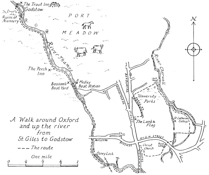
A Longer Walk around Oxford and up the River Thames from St Giles to Godstow

Undoubtedly the most famous stretch of river in Oxford is that between Folly Bridge and Iffley Lock, a section of the River Thames which is popularly known as the Isis. It is here that the college rowing crews race against each other in the two annual regattas - Torpids in late February and Eights in mid May. Most of the College Boathouses are on the north bank which may be approached through Christ Church Meadow; the towpath, however, is on the south bank, and runs past the ruins of the University boat club (OUBC) headquarters, which burnt down in mysterious circumstances in Autumn 1999 (Cambridge lost the boat race that year). Iffley Lock is about 1.5 miles from Folly Bridge (which incidentally is the site of the original ford from which Oxford gets its name); some may be heartened to know that there is a pub at each end (The Head of the River at Folly Bridge, and The Isis Farmhouse at Iffley Lock).
There are a number of pleasant walks by the River Cherwell. Addison's Walk is accessible from Magdalen College – unfortunately the college charges admission to non-University members in the Summer months. Before Magdalen improved security at its back gate, it was possible to walk through to Mesopotamia. Nowadays this verdant and shaded path may be reached from the University Parks. It takes you through to Marston Road, where you can cross straight into Headington Hill Park, through to cross over Headington Road, and thence all the way into South Park keeping to green spaces nearly all the way.
A very pleasant walk is provided by following the river North from the Parks: cross Rainbow Bridge and follow the path (which can get a little bit muddy in places) on the east bank. Lady Margaret Hall and the Cherwell Boathouse pass on the opposite bank before a footbridge is reached which gives access to Wolfson College and thence to the city. Alternatively, you may continue to walk north for a further half-mile when you will reach the Marston Ferry Road Bridge and, just beyond, the Victoria Arms – an idyllic pub, especially in the summer, which serves good food as well as a fine selection of well-kept ales. (The Victoria Arms is also a favourite destination for punters. Those who start on the lower part of the river, by Magdalen, have to negotiate the rollers before bearing left round the parks to reach it.)
The upper reaches of the Thames in Oxford cross Port Meadow, a beautiful open pasture, accessible from Walton Well Road (off Walton Street, North Oxford). Beyond the gate at the end of the road is a well-defined path leading to the Thames – cross two bridges, the first wooden, the next arched steel, to reach the towpath, which runs north along the west bank. This path can also be reached by following the river up from the Botley Road (go under the railway bridge and keep going, then turn and follow the river when it appears on the right), or for the energetic, all the way from Folly Bridge, past Osney Lock.
Following the Thames north, with Port Meadow on the right, one finds two splendid pubs. The Perch at Binsey is the first of these; it serves excellent food and you can sit out in the garden in the summer. The Trout is about one mile further on, past Godstow Lock and the ruins of Godstow Nunnery, and next to the road bridge crossing the Thames; the pub overlooks a waterfall and a very picturesque footbridge over the river, and peacocks and swans are often to be seen in the grounds. It's recognisable as one of Morse's favourite watering holes. The easiest way back is the way you came, but the weary can follow the road over the river to Wolvercote, from where you can get a bus or taxi back to the city centre.


